Media FAQ: Honduran Expedition – February 2015
Over an 11 day period in February, 2015, an interdisciplinary team of archaeologists and other scientists explored and documented a remote valley in the Mosquitia region of Honduras. Over the next few years, the team will be analyzing and publishing its findings in peer-reviewed scientific journals.
In addition to the upcoming scientific publications that will result from this expedition, the Instituto Hondureño de Antropología e Historia (IHAH) and the Honduran President asked the team to announce its findings immediately. They did so through a short news article written by Douglas Preston, with photographs by David Yoder, and posted on the National Geographic website. The online post highlights the important history, ecological richness, and cultural importance of the Mosquitia region. Honduran officials wanted especially to shine a global spotlight on this highly endangered area, with the goal of protecting it as a vital part of the country’s ecological and cultural patrimony. This is crucial because, at the present rate of deforestation and looting, this valley is estimated to be reached (and therefore plundered) within six to eight years. With over a million views in less than two weeks, the response to this news article has been overwhelmingly positive. The following section presents a FAQ about the project and initial results while appropriate academic materials are being prepared.
What was the purpose of the 2015 expedition?
The purpose of the expedition was to survey and record what appeared to be large, undocumented settlements (“cities” as defined anthropologically) in a remote valley in the Mosquitia. The settlements were first identified in a 2012 light detection and ranging (LiDAR) survey of the area conducted by the National Center for Airborne Laser Mapping (NCALM) and the University of Houston for Under the LiDAR Productions (UTL) with the approval of IHAH. (The May, 2013 issue of the New Yorker Magazine carried a comprehensive article on this discovery, written by its archaeological correspondent, Douglas Preston). None of these settlements had been documented in academic publications, in unpublished project reports, or in any other documents present in the IHAH archaeological archive maintained in Tegucigalpa. Prior to the first airborne survey of 2012, IHAH’s then head of cultural patrimony was consulted in 2011 in order to avoid areas with already registered sites. The sites were not in the Honduran Government database of cultural patrimony.
Who sponsored the expedition?
The expedition was sponsored by UTL and the Honduran government with additional support from NCALM/University of Houston and Colorado State University. It included Honduran and American archaeologists, anthropologists, engineers, and other scientists. It was conducted under the auspices of IHAH, directed by Virgilio Paredes Trapero, with the assistance of the Honduran military and the President of Honduras. All relevant permits were acquired.
Who were the scientific personnel on the expedition?
The expedition included Honduran and American archaeologists from leading universities and organizations, an anthropologist (to analyze the broader cultural context of the site’s material culture and to continue ongoing ethnographic analysis among the indigenous groups of the Mosquitia), two ethnobotanists (to make observations of plants important to indigenous people, especially plants that might be a “legacy” from the time of human occupation), and a LiDAR engineer with a portable Terrestrial Laser Scanner (TLS) provided by Riegl USA to NCALM to document any finds in situ. A full list of expedition personnel appears below.
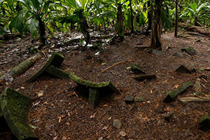
What did the team find?
Through the 2015 fieldwork the team was able to verify much of the initial 2012 LiDAR findings around one of the larger settlements, as well as document many features not visible in these data by verifying a sample of the overall LiDAR data. Through this work the team demonstrated that these settlements were embedded within a human-modified landscape that includes roads and paths, water control features such as reservoirs and canals, possible river channel modification, and agricultural terraces. This research adds a new chapter to an existing body of evidence demonstrating that the Mosquitia region was densely settled in the past. A pristine, undisturbed, and important cache of 52 ground-stone objects was located and documented both photographically and using the TLS scans to create a 3D image of the cache with a resolution of 1cm or better, without a single object being disturbed. No excavations were undertaken; everything was left in situ.
What does this say about LiDAR technology?
The multi-level tropical forest of la Mosquitia represents some of the densest vegetation cover in the world. The UTL project demonstrates that LiDAR can penetrate even this heavy vegetation cover to produce meaningful results. In many respects this represents the ultimate demonstration of this technology, which was used for the first time to explore an unknown region for archaeological features. It also means that many areas of the world for which little archaeological data exist due to heavy vegetation, rugged topography, or other limitations can now be mapped and explored to record global patrimony and develop preservation plans.
What are the ecological implications of this work?
Though the focus of the UTL team to date has primarily been on the archaeology of the study areas, the implications for the ecology of the region are just as important. The LiDAR record generated by this project includes a comprehensive, three-dimensional, database containing extensive information about the vegetation hydrology, topography, and geology within the regions investigated. This constitutes an extraordinary compendium of data that will prove invaluable for the eventual conservation of this region.
What permits and permissions were obtained?
All relevant Honduran legal regulations were strictly followed and the appropriate permits were obtained from IHAH. No excavations were allowed, and all care and respect was taken to leave the sites as they were found with the goal of returning for long-term systematic investigation by an international research team that will include Honduran researchers and students.
Were Honduran researchers included on the team?
The 2015 field team consisted of seven scientists including two Honduran researchers in lead roles on the project. Oscar Neil Cruz, who is the lead archaeologist for IHAH and who has worked in the Mosquitia region, collaborated with the team throughout the duration of the project and participated in the ground verification efforts and the archaeological interpretation of ancient settlements. Juan Carlos Fernández-Díaz is a LiDAR researcher with NCALM and the University of Houston. Dr. Fernandez has played an important role in the project from the initial LiDAR acquisition in 2012 to the ground verification efforts of 2015.
Have these sites been documented before?
The settlements documented through LiDAR and verified by the 2015 fieldwork do not appear in academic publications and have not been mentioned in project reports and other documents present in the official IHAH archaeological archive maintained in the Honduran capital city Tegucigalpa. Importantly the sites have not been previously registered with the Honduran Government in its database of cultural patrimony. Neither the ruins nor the surrounding rainforest showed any evidence of recent human habitation or intrusion.
Were local people, or evidence of modern people, present at the locations investigated?
The specific area investigated is a pristine tropical wilderness with no evidence of modern human settlement, roads, agriculture, pathways, or other presence. Botanists who were part of the team concur with these findings. This is also consistent with the 2012 LiDAR results which clearly show no human-generated clearing, deforestation, or other intrusion. To be able to tread lightly in this tropical wilderness was a privilege that has been acknowledged by every member of the team.
By contrast, the team’s ethnographer, Dr. Alicia M. González, met with members of local indigenous Miskito and Pech communities. The overwhelming concern voiced was about the impact of deforestation on their lives, especially those whose livelihoods are dependent on the rivers: “Se están secando los ríos porque cortan los arboles y se van los animales porque no tienen comida, y hay menos pescado.” (“The rivers are drying. They cut the trees and the animals leave because there is no food and there are less fish.) Dr. González also worked with several Honduran special forces soldiers who are Pech, Miskito, Garifuna and Tawahka who were being trained to safeguard the Biosphere. The valley we investigated is approximately 75 kilometers from the nearest indigenous Pech village.
Are the settlements documented through LiDAR and ground verification the legendary la Ciudad Blanca?
At no time in any print or media venue has any member of the team declared that any of the settlements that we have been able to document correspond to the place known in Honduran oral tradition as “La Ciudad Blanca” or that has been popularized outside of Honduras as the “Lost City of the Monkey God”. The news article on the National Geographic magazine website made the point: there are many lost cities. However, the importance of this place called ‘Casa Blanca’ as part of the intangible national heritage of Honduras, and particularly of the indigenous peoples of La Mosquitia, has never been negated.
How have team members recognized previous academic work within the Mosquitia?
In our scholarly work dealing with the Mosquitia region, we applaud and recognize the contributions of previous researchers, both local and foreign. Since 2012, this includes two peer-reviewed academic publications and papers presented at four academic conferences in the United States, Honduras, and Europe. All of this work includes extensive bibliographies with scholarly citations as vetted by the peer-review process. It should be recognized that the short news announcement by Douglas Preston posted on the National Geographic magazine website on March 2nd is not an academic piece, and as such does not include citations. In his longer 2013 New Yorker article on the project in May of 2012, to which the news piece visibly linked, Preston included significant sections on previous work, along with interviews with many scholars engaged in research within Honduras.
What is the current ecological status of the Mosquitia region?
The Mosquitia Biosphere is clearly endangered. From 1990 to 2005 37.1% of Honduran forest cover was destroyed to illegal logging and deforestation – largely for beef production. In 2011 the reserve was placed on the UN danger list at the request of the Government of Honduras as a result of “Illegal settlement by squatters, illegal commercial fishing, illegal logging, poaching and a proposed dam construction”. In the two years since our three areas of investigation were documented using LiDAR, illegal clearing and deforestation has approached within 12 miles of one valley, and has decimated the floor of a second. Ancient settlements now visible in recently cleared areas of the biosphere are presently undergoing looting and damage. Undoubtedly something must be done to stem the tide of this loss.
What has been the Honduran Governmental response to our work?
After the announcement of the initial LiDAR findings in 2012 former president Porfirio “Pepe” Lobo Sosa created an archaeological preserve to help protect the cultural patrimony of the region. Efforts are underway to strengthen these protections. Virgilio Paredes Trapero, current director of IHAH has stated that international resources are necessary to further protect the extended Río Plátano Biosphere Reserve in which the valley we investigated in 2015 is embedded.
What do we envision as the preferred outcome of our work?
It must be emphasized that the ultimate goal of our work is to highlight the rich cultural and ecological patrimony of this endangered region so that international cooperation and resources can be brought to bear to help initiate effective conservation. To lose the rich ecological and cultural patrimony of la Mosquitia to deforestation and associated land perturbation would be a global loss. We are convinced that this sentiment is shared by the many current and past researchers who have worked in the region. The team urges those archaeologists and others concerned about Honduras and its unique cultural patrimony to please join us in this crucial effort, which will take the synergy of collaboration and goodwill among all involved.
We hope our colleagues will realize the enormous contribution and attention that this project has brought, not only to the academic community working in the area but to the people and government of Honduras, and we hope that together we will be able to foster and encourage greater academic research in the area.
To this end the UTL team members propose an academic workshop on the current status of ecological and archaeological work within la Mosquitia, along with future directions for conservation and action, to be held in 2015. Colorado State University has generously offered to host this meeting on the Fort Collins, Colorado, USA campus. Christopher Fisher (ctfisher@lamar.colostate.edu) will be the point person for this inclusive conference.
Project Personnel:
Mr. Bill Benenson, UTL Scientific L.L.C. Filmmaker
Mr. Steve Elkins, UTL Scientific, L.L.C. Filmmaker, Project Lead
William E. Carter Ph.D., Professor and Senior Research Engineer, National Center for Airborne Laser Mapping, University of Houston
Oscar Neil Cruz Castillo, Lead Archaeologist, Instituto Hondureño de Antropología e Historia (IHAH)
Juan Carlos Fernandez-Diaz Ph.D., National Center for Airborne Laser Mapping, University of Houston
Christopher T. Fisher, Ph.D., Associate Professor of Anthropology, Colorado State University
Alicia M. González, Ph.D., Independent Anthropologist & Ethnographer, formerly, Smithsonian Institution, National Museum of the American Indian
Stephen Leisz Ph.D., Associate Professor of Geography, Colorado State University.
Mark Plotkin Ph.D., President, The Amazon Conservation Team.
Luis Jorge Poveda Álvarez Ph.D., Biologist, Professor, National University of Costa Rica
Douglas Preston, Writer, National Geographic Magazine
George Rossman, Ph.D. Professor of Mineralogy, Division of Geological and Planetary Sciences, California Institute of Technology
Michael Sartori M.Sc, National Center for Airborne Laser Mapping, University of Houston
Ramesh L. Shrestha, Ph.D., Director National Center for Airborne Laser Mapping, University of Houston
Abhinav Singhania, National Center for Airborne Laser Mapping, University of Houston
Dan Thompson, Ph.D. Archaeologist, formerly Director of Global Projects at The Global Heritage Fund
Tom Weinberg, Adjunct Professor, Media Ecology, Columbia College, Chicago
David Yoder, Photographer, National Geographic Magazine
Media Inquiries: Maggie Begley/MBC